Bob Ransford
Sun

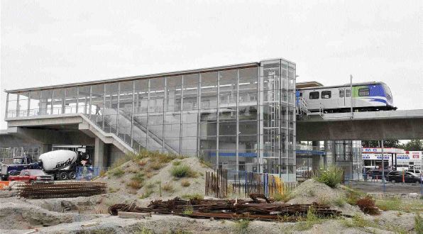
The Canada Line will be going into service Monday, well ahead of schedule. Photograph by: Jenelle Schneider, Vancouver Sun
Monday, the Richmond-Airport-Vancouver Rapid Transit Project, now known as the Canada Line, will begin operating.
This $2-billion-plus public infrastructure project has been in the works for nine years now.
Two weeks ago, Vancouver city council approved the terms of reference for a planning program that will end up in the fall of 2011 with policies in place that direct how development might occur within a 500-metre radius around four of the transit stations along the Cambie corridor south of 16th Avenue. No plans are in place yet for special re-development around the two other stations outside the downtown.
Once the new policies are in place, it will likely take any property owner at least another two years to rezone a property for higher density redevelopment around these transit stations. Construction will take about two more years, with the first of any new transit-influenced housing or commercial development along the Cambie corridor opening its doors in late 2015 at the earliest.
The location of the stations was pretty much cast in stone early in 2002. The full scope of the project with precise station locations was detailed in February 2003 in the Project Definition Report.
So, in short, urban planning and design is lagging behind public infrastructure by almost a decade and a half. Something is wrong with this picture.
Land use and transportation infrastructure planning are supposed to go hand-in-hand. Transit supports the movement of people who live and work in more dense development around transit stations and more dense development around transit stations support ridership on transit systems.
Study after study demonstrates that by strategically locating transit supportive uses and density along transit corridors, we can significantly reduce greenhouse gas emissions. Higher density buildings have smaller carbon footprints and by providing easy access to public transit, there are sharp declines in vehicle miles travelled.
Despite all of the talk about improving public transit infrastructure in Metro Vancouver to promote more compact communities and ultimately reduce greenhouse gas emissions, we can’t seem to get the timing to mesh between land use planning and transit infrastructure.
Coquitlam town centre has taken shape as a relatively dense mixed-use town centre. In fact, there has been enough density in the area for probably a decade to support a mass transit system extending to the heart of the town centre. Meanwhile, the launch of the Evergreen Line rapid transit project is stalled over the last dollars of funding needed.
Almost since the day the SkyTrain Expo Line opened in Surrey in the early 1990s, the City of Surrey has been working to develop Surrey City Centre a regional downtown and as the main business, cultural, and activity centre for the city and the South Fraser region. It’s probably come the closest to having policies in place to support dense development and in attracting some of that development. However, it is again density following in the path of infrastructure by years rather than months.
When Vancouver planning staff presented their two-year work plan to city council for the Cambie corridor planning, they reminded council that they originally intended to plan only one station at a time along Cambie–a process that would have taken six to eight years to complete for the four stations.
Thank goodness they reconsidered “in order to address opportunities and challenges in a more timely and coordinated manner and to realize efficiencies in plan delivery.”
We need to find a better way of coordinating land use planning and transit infrastructure planning. The current model isn’t working.
Bob Ransford is a public affairs consultant with CounterPoint Communications Inc.
He is a former real estate developer who specializes in urban land use issues.
E-mail: [email protected]
© Copyright (c) The Vancouver Sun

