Stunning satellite images show the planet as astronauts see it
Randolph Schmid
Sun
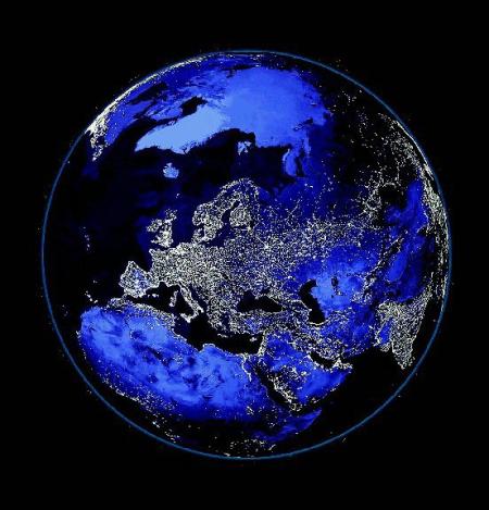
Streetlights on Earth at night are seen in an image from an exhibit at the National Air and Space Museum in Washington. Photograph by : Associated Press
WASHINGTON — Science and art merge in a stunning new Smithsonian museum exhibition featuring planet Earth as seen from above.
Some of the satellite images show the home planet as only astronauts can see it; others taken with special instruments show things even they can’t see.
There’s a myth that the Great Wall of China is the only manmade object that can be seen from space, but that’s not true, exhibit curator Andrew Johnston said.
And he proves it, pointing out satellite images of the Great Pyramids, downtown San Francisco, New Orleans while flooded by hurricane Katrina, container ships in the harbour of Hamburg, Germany, and a nighttime view of the globe with city lights.
Johnston, a geographer at the Smithsonian’s National Air and Space Museum, organized the exhibit, which opens Saturday. It will remain at the Air and Space Museum until Jan. 7 and then begin a tour of cities around the U.S.
The images were made by a variety of satellites operated by government and private companies. Most of the satellites circle the globe at around 1,000 kilometres altitude; captions on each picture show the satellite that took it.
One unique shot shows Mount Taranaki, New Zealand, surrounded by what looks like a circular shadow.
It turns out to be Egmont National Park, which was created by drawing a circle around the mountain. The dark area inside the circle is forest reserve, the lighter surrounding lands are farms.
For people who have vacationed in the Caribbean, there’s a view of those islands highlighting the shallow water around them and the darker deep water nearby.
Clouds blowing along the ocean break into great swirls and twists where islands reach up into them, images reminiscent of the bow-wave of a giant vessel.
Also evoking the ocean are wave after wave of sand in Yemen, contrasting with blue rocky land nearby.
The picture is said to include the border between Yemen and Saudi Arabia, though in this uninhabited area that line has yet to be surveyed.
Perhaps the most striking image is the multicolour picture of the great delta of the River Lena in Siberia. The dark blue river divides into twists and turns and threads through the green land in this summer view of the area.
The Nile Valley glows with light in a composite nighttime image of the Eastern Hemisphere.
The great cities of Europe — London, Paris, Madrid, Berlin — sparkle. It’s possible to trace railroad lines in Russia, and at the far edge Japan is a bright crescent.
Most of the images in the exhibit come from Johnston’s 2004 book Earth From Space, though new ones, such as flooded New Orleans, have been added.
– – –
ON THE NET
Earth From Space: http://www.earthfromspace.si.edu
National Air and Space Museum: http://www.nasm.si.edu
Smithsonian Institution Traveling Exhibition Service: http://www.sites.si.edu
© The Vancouver Sun 2006
