As rural areas decline, B.C. has become the most urban province in Canada
Frances Bula, with files from Peter O’Neil
Sun
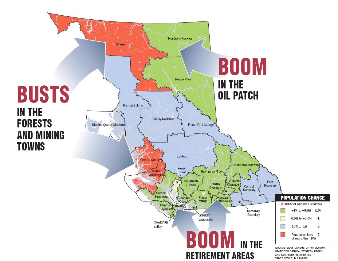
Busts in the Forests and Mining TownsBoom in the Oil Patch Boom in the Retirement Areas Photograph by : 2006 Census of Population, Statistics Canada, Western Region and Northern Territories; Vancouver Sun Graphic
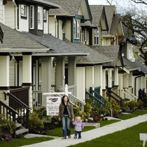
A young mother holds her daughter outside their townhome in the new Foxridge housing development on 60th Avenue near 166th Street in Surrey. Four of the five fastest-growing neighbourhoods in the province are located in Surrey. Photograph by : Mark van Manen, Vancouver Sun
We think of ourselves as living in a province of forests and fish, mines and ranches, with towns and cities to match.
But we’re really city and suburban people surrounded by mostly empty mountains, according to the census snapshot from Statistics Canada.
B.C., which has broken the four-million mark in population, is the most urban province in the country, according to the 2006 census statistics released Tuesday.
Only 15 per cent of its population now lives in rural areas, and residents are draining steadily away from the former thriving resource towns of the northwestern B.C. and the central coast.
The province has grown by 5.3 per cent, thanks mainly to immigrants from outside Canada, since B.C. has the lowest birthrate in the country.
However, those immigrants, along with younger people from the declining northern towns, are going almost exclusively to B.C.’s growing urban regions, with places like Kelowna and Abbotsford among the fastest-growing cities in the country.
The result is that most of the people in this huge province are increasingly shoehorned into a few valleys along major highways: The Greater Vancouver region, which has now gone over the two-million mark, the Central Okanagan, and the Vancouver Island east coast from Victoria to Nanaimo.
The Yamashitas of Terrace see that story played out in their family.
Their ancestors came to B.C. at the turn of the century, settling in Port Essington near Prince Rupert with other Japanese immigrants to fish the Skeena River.
Tosh Yamashita, a child of the post-war generation, worked in Terrace as a planner for the past 25 years.
Now, his three boys, all in their 20s, are living in the Vancouver region: Jason is studying law; Kasel is working at a lumberyard; and Kory, the youngest, is finishing his engineering degree.
Only Kory plans to return, wanting to live where the traffic and house prices are reasonable and where he knows everyone in town.
But he’s an anomaly, says his brother.
“People don’t go back because there’s no jobs there. The pulp mill is suffering, the sawmill is closed,” says Jason, now 28. “The vast majority of my graduating class is in Prince George, Victoria, Vancouver, Calgary, Montreal, Toronto.”
That’s a story being told throughout the north, with Kitimat, Prince Rupert, Quesnel, Terrace and Williams Lake showing the biggest population losses of all mid-size cities in Canada.
University of B.C. geography professor David Ley says that north-south divide in B.C. is the most striking story in the statistics.
“This is quite a novel demographic moment,” said Ley, noting that cities have seen striking changes, with Prince Rupert losing 12 per cent of its population and Kelowna gaining 10 per cent.
“These are big numbers in a very short time. It does tell a tale about job loss in the resource industry. There’s quite an inequality between the two regions.”
One area of northern B.C. that is bucking the trend is the northeast corner, where population grew slightly because of jobs in the oil industry. That likely helped, in part, reverse the trend that showed up in the 2001 census, which saw B.C. losing population to other parts of the country.
This time, B.C. went back to its traditional pattern of attracting people from other provinces.
The trend of population movement toward cities is prevalent across Canada.
Canada’s six largest cities — Toronto, Montreal, Vancouver, Ottawa-Gatineau, Calgary and Edmonton — are home to 14.1 million people, or 45 per cent of the total population.
Just over two-thirds (68 per cent) of the population lives in Canada’s 33 census metropolitan areas.
But B.C. is slightly more urbanized than the national trend, with 85.4 per cent of people living in urban areas here compared to an 80-per-cent average for the country.
That’s likely due to the province’s geography, economic context and its immigration pattern, experts suggest.
B.C. is more dependent on overseas immigrants than any other part of the country, says Ryan Berlin, an analyst with the Urban Futures Institute.
“We’re not seeing immigrant families going straight to Kitimat,” said Berlin. Instead, they are clustering in particular sectors of the Lower Mainland.
Statistics Canada noted that “between 2001 and 2006, an average of 25,000 immigrants a year settled in the Vancouver area. Because of international immigration, Vancouver continued to experience a higher population growth rate than the provincial average in the 2001 to 2006 period (6.5 per cent versus 5.3 per cent).”
As well, B.C.’s mountains produce a different population distribution.
People here aren’t spread out on the kind of farmland that southern Ontario or the Prairies have.
“We are seeing all the growth being concentrated along the Trans-Canada Highway corridor and the Island Highway,” says Berlin.
Finally, rural cities and towns have always been more dependent on the fluctuations of the resource industry, rising and falling with the ups and downs of mining, forestry, fish and oil.
The northeast sector is booming now. “But if oil falls back down to $30 a barrel, there’ll be an exodus,” said Berlin.
The Greater Vancouver region saw 6.5-per-cent growth, lower than in Calgary, Edmonton and Toronto, but higher than the national average.
Its growth was uneven, however, with suburbs like Port Moody and Surrey gaining population at Calgary-like rates, while others — Delta, West Vancouver, Langley city, Coquitlam, and North Vancouver — showed little or no growth.
Like the province, its growth is shaped by its geography and transportation lines.
“The urban spread in Vancouver is uniquely influenced by our terrain and the SkyTrain and West Coast Express,” said Jerry Page, the director for Statistics Canada’s western region.
B.C. GAINERS
Biggest gainers in actual population
2006 2001 Change % change
Surrey 394,976 347,820 47,156 13.6%
Vancouver 578,041 545,671 32,370 5.9%
Kelowna 106,707 96,288 10,419 10.8%
Richmond 174,461 164,345 10,116 6.2%
Burnaby 202,799 193,954 8,845 4.6%
Abbotsford 123,864 115,494 8,370 7.2%
Langley 93,726 86,896 6,830 7.9%
Chilliwack 69,217 62,567 6,650 10.6%
Maple Ridge 68,949 63,169 5,780 9.2%
Nanaimo 78,692 73,000 5,692 7.8%
B.C. DECLINERS
Biggest decliners in actual population
2006 2001 Change % change
Prince Rupert 12,815 14,643 -1,828 -12.5%
Prince George 70,981 72,406 -1,425 -2.0%
Kitimat 8,987 10,285 -1,298 -12.6%
Terrace 11,320 12,109 -789 -6.5%
Port Hardy 3,822 4,574 -752 -16.4%
Quesnel 9,326 10,044 -718 -7.1%
Mackenzie 4,539 5,206 -667 -12.8%
Fort St. James 1,355 1,927 -572 -29.7%
Lillooet 2,324 2,741 -417 -15.2%
Houston 3,163 3,577 -414 -11.6%
